- What does a Map Of Ancient Nile reveal about its geography?
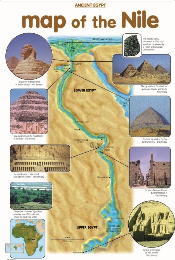
A Map Of Ancient Nile typically highlights the fertile Nile River Valley, the expansive Nile Delta stretching to the Mediterranean Sea, and the surrounding desert landscapes. It showcases the division into Upper and Lower Egypt, distinct by their elevation and river flow, and often includes key cataracts that marked natural boundaries. These maps are crucial for understanding the river's life-giving role in an otherwise arid region.
- Why was the Nile River so important to ancient Egyptian civilization?
The Nile River was the lifeline of ancient Egypt, providing essential resources. Its annual inundation deposited rich, fertile silt, enabling agricultural prosperity for crops like wheat and barley. The river served as the primary mode of transportation for goods and people, facilitating trade and communication throughout the kingdom. It also deeply influenced their religious beliefs, mythology, and daily life, shaping the very foundation of their society.
- How did ancient Egyptians navigate and map the Nile?
Ancient Egyptians relied on visual landmarks, knowledge of the river's flow, and celestial observations for navigation. While formal cartography as we know it was limited, they created detailed pictorial representations on temple walls and papyri depicting specific areas, trade routes, and sacred sites along the Nile. Their practical understanding of the river's cycles was a form of mapping essential for farming and travel.
- What are some major ancient cities located along the Nile River?
Numerous significant cities flourished along the Nile. In Lower Egypt, major centers included Memphis, the ancient capital, and later Alexandria, a Hellenistic hub. In Upper Egypt, Thebes (modern Luxor) was a prominent religious and administrative capital, home to Karnak and Luxor Temples. Other important sites included Abydos, a sacred burial ground, and Edfu, known for its well-preserved temple to Horus. Each city played a crucial role in Egyptian history.
- Are there different types of historical maps for the Ancient Nile?
Yes, historical maps of the Ancient Nile vary. Some are archaeological maps detailing excavation sites and temples, while others depict the political divisions or trade routes of different dynasties. Ancient Egyptian "maps" were often conceptual or functional, like tomb plans, rather than geographical surveys. Later, Greek and Roman cartographers, like Ptolemy, created more recognizable geographical maps integrating the Nile, offering different perspectives on its representation.
- How has the course of the Nile River changed since ancient times?
The overall course of the Nile River has remained remarkably consistent, a testament to its geological stability. However, localized changes have occurred, particularly in the Nile Delta region due to sediment deposition and shifting distributaries. Human intervention, such as the construction of dams (e.g., Aswan High Dam), has significantly altered the river's annual flooding cycle and sediment distribution, impacting the landscape compared to ancient times.
- Where can I find digital high-resolution images of ancient Nile maps for study?
High-resolution digital images of ancient Nile maps are available through major museum websites, such as the British Museum, the Metropolitan Museum of Art, and the Louvre. University digital libraries specializing in ancient history or Egyptology, like the University of Chicago's Oriental Institute, also offer extensive collections. Look for "digital archives" or "online collections" on their institutional websites for direct access to these valuable resources.
Dive into the captivating history of the Map Of Ancient Nile a vital artery of civilization. Explore its historical significance geographical features and how it shaped ancient Egyptian culture. Understand the Nile River Valley its cities and surrounding regions through detailed cartography. This guide provides navigational insights for students historians and enthusiasts offering a glimpse into one of the worlds most influential rivers. Discover how ancient peoples charted their world along this majestic waterway and learn about the evolution of mapping techniques. From agricultural bounties to trade routes the Nile was central to life. Uncover archaeological sites and historical landmarks as depicted on ancient maps. Modern digital tools can now bring these historical maps to life providing context and rich detail for your exploration of this iconic region. This trending topic offers deep dives into one of humanitys most fascinating waterways.
- What is the primary focus of an Ancient Nile Map? - An Ancient Nile Map primarily showcases the Nile River's geographical and cultural significance, highlighting the fertile valley, the Delta, and surrounding desert regions. It illustrates major ancient cities, temples, and the division of Upper and Lower Egypt, providing a visual understanding of how the river sustained one of the world's greatest civilizations.
- How did the Nile River influence ancient Egyptian settlements? - The Nile River critically influenced ancient Egyptian settlements by providing water, fertile land through annual flooding, and a vital transportation route. Most major cities, such as Thebes and Memphis, were strategically located along its banks to maximize access to resources, facilitate trade, and enable defense. Its predictable cycles underpinned their agricultural calendar and community life.
- Where can I access authentic digital maps of the Ancient Nile today? - Authentic digital maps of the Ancient Nile are best accessed through the online archives of reputable institutions. Look for digital collections from the British Museum, the Louvre, the Metropolitan Museum of Art, and university Egyptology departments. These sources provide high-resolution images and scholarly context, ideal for research and general interest.
- What key landmarks are typically featured on maps of the Ancient Nile? - Maps of the Ancient Nile typically feature iconic landmarks such as the Great Pyramids of Giza, the temples of Karnak and Luxor, the Valley of the Kings, and significant ancient cities like Memphis and Thebes. The various cataracts and the expansive Nile Delta are also prominent, illustrating the geographical features that defined the ancient Egyptian landscape.
- How does a Map Of Ancient Nile differ from a modern map of Egypt? - A Map Of Ancient Nile differs from a modern map of Egypt by emphasizing historical geographical features, ancient city locations, and political divisions of bygone eras. Modern maps, conversely, show current political boundaries, contemporary infrastructure, and the current course of the river, often altered by dams. The ancient map provides a historical snapshot.
- What role did the Nile Delta play on an Ancient Nile Map? - On an Ancient Nile Map, the Nile Delta played a crucial role as a highly fertile, fan-shaped region where the river branched into multiple distributaries before meeting the Mediterranean Sea. It was a center for agriculture, trade, and settlement, often depicted with numerous cities and harbors that were vital for Egypt's economy and connection to the broader ancient world.
- Can I use an Ancient Nile Map to understand ancient trade routes? - Yes, an Ancient Nile Map is invaluable for understanding ancient trade routes. The Nile itself was the primary artery for internal trade, connecting Upper and Lower Egypt. Maps often illustrate desert routes linking to mining regions or coastal paths for international maritime trade, showing how goods flowed from Nubia to the Mediterranean and beyond, all centered around the river.
Ever wondered how ancient civilizations thrived along the mighty Nile? The Map Of Ancient Nile provides a fascinating window into this vibrant past. For Gen Z and Millennials seeking to connect with history through digital exploration, understanding these maps unlocks untold stories of pharaohs, pyramids, and pioneering societies. Get ready to navigate the heart of ancient Egypt, right from your device.
Frequently Asked Questions
Where can I find the most detailed maps of the Ancient Nile?
The absolute best locations to explore detailed maps of the Ancient Nile are leading institutions like the British Museum Digital Collection, the Louvre's online archives, and university libraries with extensive Egyptology departments.
How do I use modern Maps to trace the Ancient Nile?
Pull up your preferred mobile Maps app and use the satellite view to overlay your understanding of ancient geography. Many historical mapping projects offer KMZ files you can import. Verify real-time historical interpretations as new discoveries refine our knowledge of the ancient river's path.
What are the best digital resources or apps for exploring Ancient Nile maps?
For an immersive experience, consider apps like "Ancient Egypt HD" or interactive websites from institutions like the Oriental Institute of the University of Chicago. These platforms often provide layered maps showing ancient settlements, temples, and the Nile's historical course.
Quick Local Guide: Key Ancient Nile Locations
- Memphis - Lower Egypt, near modern Cairo
- Thebes (Luxor) - Upper Egypt, East Bank of the Nile
- Abydos - Upper Egypt, West Bank of the Nile
- Aswan (Syene) - Southern Egypt, First Cataract region
- Alexandria - Nile Delta, Mediterranean Coast
- Giza - Lower Egypt, West Bank of the Nile
All maps focus on Map Of Ancient Nile.
Understand the Nile Rivers pivotal role in ancient civilization Explore its key geographical features and historical settlements Learn about ancient Egyptian mapping techniques Discover how digital tools enhance the study of ancient Nile maps Navigate significant historical sites along the river.


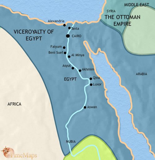


Ancient Egypt Nile River Map Map Of Ancient Egypt Nile Map On The Nile Map Of The Nile River In Ancient Egypt Egypt Tours Portal . Ancient Nile River Valley Map Latest. Ancient Egyptian Nile River Map Egypt1837ad . Nile River Valley Map Il T7p9 . Ancient Map Of The Nile Egypt S River Of Ancient Nile Map
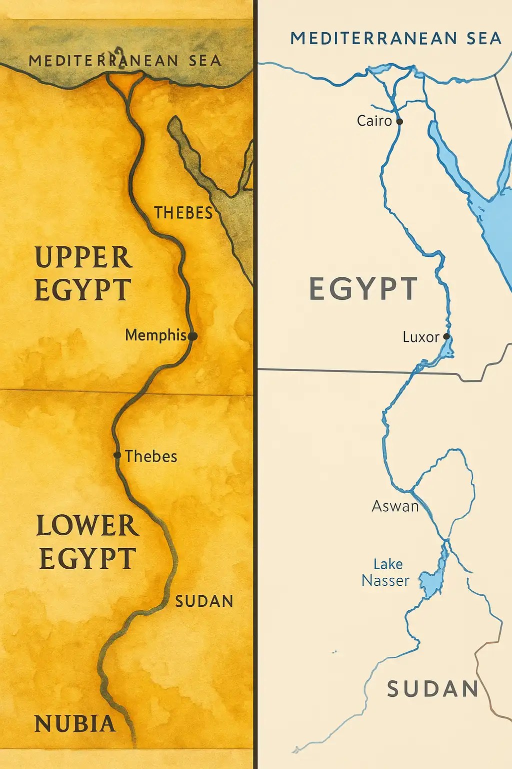


Ancient Map Of The Nile Egypt S River Of Comparing Nile Maps. Ancient Egyptian Nile River Map . Nile River Basin Map Egypt Map Ancient Egypt Map Nile River Nile And Delta . Herodotus The River Nile Storynory All For One Map Ancient Egypt Less . Nile River Cruises Ships And Itineraries 2025 2026 2027


Ancient Egyptian Nile River Map Nile Basin Map Egypt . Map With Nile River Crucial Shift In River . Ancient Nile River Map . Premium Photo This Is An Of A Detailed Map Of Ancient This Is Detailed Map Ancient Egypt Map Shows Nile River Valley Kings Other Landmarks 14117 482190 . 2026 Legends Of The Nile ASU Alumni EGYPT26 Map


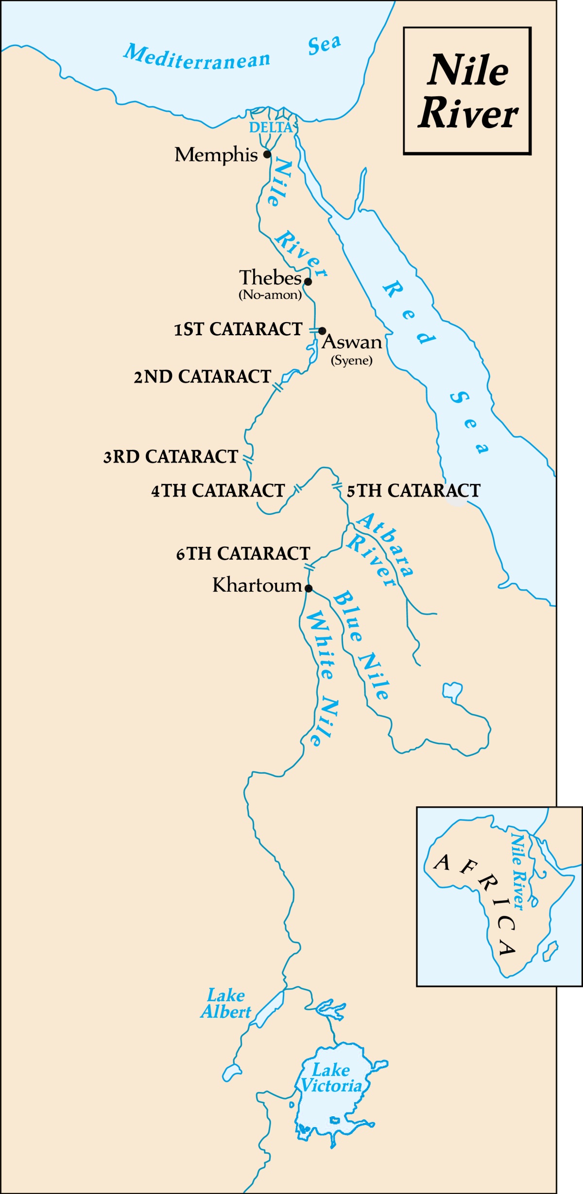

Ancient Egyptian Nile Map . The Nile River Valley And Its Lives And Fiveable Image. Nile River Source Country Map Of The Nile River In Egypt . Egypt Cataracts Map Ancient Egypt 161. World Map Nile River BG Nile Climate Map 01


Nile Valley Map RIVER VALLEY Old World Nile Valley . Ancient Nile River Valley Map C9NFx 4t05.LZS Xoq9Dfg . Ancient Egyptian Nile Map S L1200 . Western Desert Egypt Map Nile EUG Ancient Egypt Nile Color . With Ancient Egypt 3d Map Of The Nile River Gallery For Ancient 329787328 Stock Ancient Egypt Map With Important


Nile River Basin Map Egypt Map Ancient Egypt Map Nile River Stock Vector Nile River History Lesson Maps M S R Skenderiye Nil Nehri Tarih Haritalar Osmanl 2217301053 . Ancient Egypt Nile River Map Canal Of The Pharaohs Wikipedia Il 1xz9 . Tracing The Footsteps Of Jesus Where Did He Live In Egypt Ancient Map Of The Nile.webp. THE NILE ALEXANDRIA TO ASWAN ILLUSTRATED In 2025 Ancient Maps . Egypt Map Nile River Map Of Europe And North Africa Egypt Map With Cities


Ancient Nile River Map 18 Isaiah Nile River Valley Copyright Stephen M Miller 1000PX . Ancient Egypt Nile River Map Map Of Ancient Egypt Nile Map On The Nile . Ancient Egypt Nile River Map Map Of Ancient Egypt Nile Map On The Nile Basin Nile River Drainage Network Egypt Sudan Africa . Ancient Nile River Map Nile River Viking River Cruises River Cruises Africa 130571 . Promonis Educational Materials Capture 11